For more information about FalconView, please contact John Pyles, Principal Research Scientist.
An American pilot overseas sits at a laptop computer, using a specialized mapping software program along with late-breaking intelligence to plan an upcoming combat mission. At a stateside surveillance center, an intelligence analyst is running the same software on a desktop PC, tracking a suspicious vehicle at a U.S. border. And half a world away, the mapping tool is helping the pilots of a massive military cargo aircraft navigate home.
Using a single software program for a broad range of mission planning, mapping, and surveillance tasks isn’t a new concept. It’s a strategy that U.S. forces and agencies have followed for two decades, and it’s become an essential part of multiple military and intelligence operations. Consistently, the core software used is FalconView®, first developed in 1994 by the Georgia Tech Research Institute (GTRI) for the U.S. Air National Guard (ANG).
“Our current numbers on FalconView’s distribution are in the 80,000-user range – it’s used today by the military, federal agencies, and allied countries for a wide variety of intelligence, planning, and operational tasks,” said John Pyles, the principal research scientist who leads FalconView development for GTRI. “Both aircrew and analysts routinely use FalconView to help gather intelligence, and that intelligence can then become part of a FalconView mission package that pilots can rehearse almost like a video game.”
This year – FalconView’s 20th anniversary – two new editions of the program are being developed to extend the original Microsoft Windows-based 2-D version of the software:
- FalconView 3-D adds capabilities to better support surface missions carried out by ground units, ships, and others.
- FalconView Mobile extends these capabilities to tablets and smartphones.
In addition to Windows, the new FalconView versions will run on a variety of other operating systems. The work is sponsored by the U.S. Special Operations Command (USSOCOM).
The FalconView of today serves as the interface for a varied group of mission planning software tools known as the Portable Flight Planning System (PFPS), the Joint Mission Planning System (JMPS), and XPlan – all of which analyze and display vital geographical data. For the sake of convenience, users often refer to the graphical portion of these tools as FalconView.
FalconView can display many types of maps, including aeronautical charts, satellite images, and elevation maps. It also supports multiple types of overlays, allowing them to be displayed and printed over any map background.
Combined with global positioning systems (GPS), FalconView supports the use by aircraft of moving-map displays, which are more complex versions of now familiar consumer applications in which a symbol representing a cellular phone or other GPS device remains stationary on a display screen while a route map moves underneath. FalconView can also aid combat operations by displaying incoming tactical data in real time.
“FalconView serves as the framework for a wide variety of tools and increases their interconnectivity,” said Pyles. “It’s the glue that helps provide broad situational awareness to the operator.”
Major Functionality Upgrade
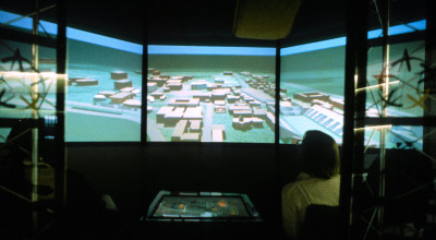
FalconView 3-D is designed to give surface-based military units an improved battlefield perspective. Unlike the traditional 2-D version of FalconView, which was developed primarily for aviation and other bird’s-eye view applications, FalconView 3-D can give those operating on the ground or water a first-person view of the surrounding area, complete with incoming intelligence data that updates the battlefield situation in real time.
“I can sit in my office and have big 3-D displays around me, but I can’t take them with me when I’m out in the field,” said David Millard, a GTRI principal research engineer who helps test FalconView products. “I want something that shows me my situational awareness in perspective, so that I can see the good guys and the bad guys relative to my position.”
This 3-D capability, Millard adds, is important to surface forces as varied as Army and Marine infantry units, tank units, and naval vessels – even Navy SEALS. Compared to a two-dimensional view from above, it can give them a more intuitive picture of their situation.
“With these tools, you can first reconnoiter the mission area on screen and basically go there before you go there,” said George Menhorn, a GTRI senior research scientist and lead engineer for FalconView. “And that usually helps a lot in locating your objective.”
The Mobile Advantage
FalconView Mobile has the potential to support both aircraft and surface units. It brings the core features of FalconView 2-D and 3-D to highly portable tablets, considered easier to handle than laptops by many users.
FalconView on a mobile device can be an important tool for surface units engaged in missions, Millard said. It provides ready access to graphics that show combat situations at a glance. Moreover, tablet computers can provide those in the field real-time access to intelligence that predicts probable enemy behavior.
Adapting FalconView to tablets can also benefit aviators, Millard explained. Mobile computing devices are currently replacing a time-honored pilots’ tool: the black flight bag. This bulky item is typically stuffed with emergency manuals, maps, and other reference materials.
Now electronic flight bags, consisting principally of tablet computers, are taking over in both the military and civilian arenas. Delta Air Lines, for example, recently announced it was supplying all its pilots with tablets.
The tablet computer’s ability to carry reams of electronic documents is important, as is its lighter weight. But its biggest advantage lies in being able to provide the latest versions of its vast electronic library.
“Paper is stale the day you print it,” said Millard. “But updates for pilots come out every five minutes, and an electronic flight bag can go out and get the most recent notices for airmen right before takeoff.”
20 Years of Experience
Acting on a request from the ANG, GTRI completed the first FalconView programs in 1994. The original GTRI development team – led by John Pyles and including Rob Gue, Jim Rhodes, and Vinny Sollicito – produced the first FalconView PC version for the MS-DOS operating system, followed shortly by a Windows 3.1 version.
Pyles said the idea for a mission-planning program that would run on the familiar PC came from a pilot named Bobby Sandford, then a captain in the ANG. Sandford wanted basic software that would give him and fellow F-16 pilots in the ANG a convenient, lower-cost alternative to the then dominant Unix mission-planning platforms.
“I wanted to avoid complexity; I wanted to provide mission-planning software that anyone could use, which would also be rock-solid and very cost-effective,” said Sandford, now a colonel and still flying fighter jets. “The engineering and the effort we got from GTRI was impressive.”
The initial version of FalconView – named after the “F-16 Fighting Falcon,” the fighter’s full name – was a set of routines that displayed scanned maps with simple stick routes drawn on top. Improved functionality followed, as the product was fleshed out by collaborations between the GTRI development team and mission planners who soon adopted the software as part of their daily activities.
As FalconView matured, USSOCOM adopted it as the framework for the entire PFPS. Important capabilities were added such as moving-map functionality, which shows aircraft location dynamically and helps provide pilots with hands-off navigation.
In 1997, the Air Force adopted PFPS, followed by the Navy in 1998, and the Army in 2002. Working with the military, GTRI gradually upgraded the program to support many platforms, including transport aircraft, helicopters, naval vessels, unmanned aerial vehicles (UAVs), and PC-based intelligence operations.
User-driven Software
Today, FalconView utilizes a range of programmer interfaces that lets multiple applications combine their information into a single coherent picture of a user’s area of interest. Moreover, the existence of the widely used FalconView standard helps users share data with other branches of the armed services and with coalition partners.
Jon R. Lindsay, a research scientist with the University of California Institute on Global Conflict and Cooperation in La Jolla, California, has written that the introduction of FalconView created strong interest among many in the military. In an article titled “War upon the Map,” published in the July 2010 edition of the journal Technology and Culture, Lindsay said of FalconView:
“Networks of enthusiastic users drove its functional evolution and diffusion into a de facto standard for geospatial information processing in the U.S. military, all for a total cost of about $20 million …. FalconView is a striking example of sustained and successful bottom-up innovation in a military environment.”
FalconView users continue to influence the program’s list of features, said GTRI researcher Menhorn. In some cases, he explained, pilots or intelligence analysts will spot a function they like in commercial flight-planning or geospatial programs and then request that it be added to FalconView.
“Adding new capabilities to FalconView is arguably an economical choice, as well as convenient,” Menhorn said. “The federal government owns FalconView, so there’s no license or update fees involved in adding upgrades, beyond GTRI’s one-time upgrade cost.”
New Operating Systems
GTRI is currently porting FalconView to a variety of platforms, in addition to Windows. These platforms include Apple Computer tablets, which use the Apple iOS operating system, and several tablets and smartphones that use the Android operating system. A version for the Linux operating system is also being developed.
The new versions will be solely for use by the U.S. military and allied nations. An open-source edition of FalconView exists; it can be downloaded by registered users in certain countries, but this edition has reduced functionality.
Development plans call for FalconView to become core to the main framework of the JMPS, the mission-planning program used by many U.S. combat aircraft, Pyles explained. FalconView maps have been a part of the JMPS system since 2002. Now JMPS will plug into FalconView, increasing JMPS’ ability to connect to a number of mission-planning software tools.
Added Sandford: “I’ve been stationed all over the world, and I can tell you that wherever you go, you’re going to see FalconView. It’s not only being used by pilots, but by the planners and the intel folks as well.”

Related News