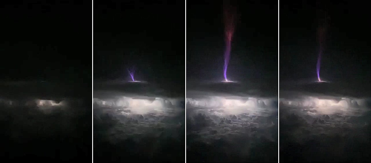
A detailed 3D study of a massive electrical discharge that rose 50 miles into space above an Oklahoma thunderstorm has provided new information about an elusive atmospheric phenomenon known as gigantic jets. The Oklahoma discharge was the most powerful gigantic jet studied so far, carrying 100 times as much electrical charge as a typical thunderstorm lightning bolt.

The gigantic jet moved an estimated 300 coulombs of electrical charge into the ionosphere – the lower edge of space – from the thunderstorm. Typical lightning bolts carry less than five coulombs between the cloud and ground or within clouds. The upward discharge included relatively cool (approximately 400 degrees Fahrenheit) streamers of plasma, as well as structures called leaders that are very hot – more than 8,000 degrees Fahrenheit.
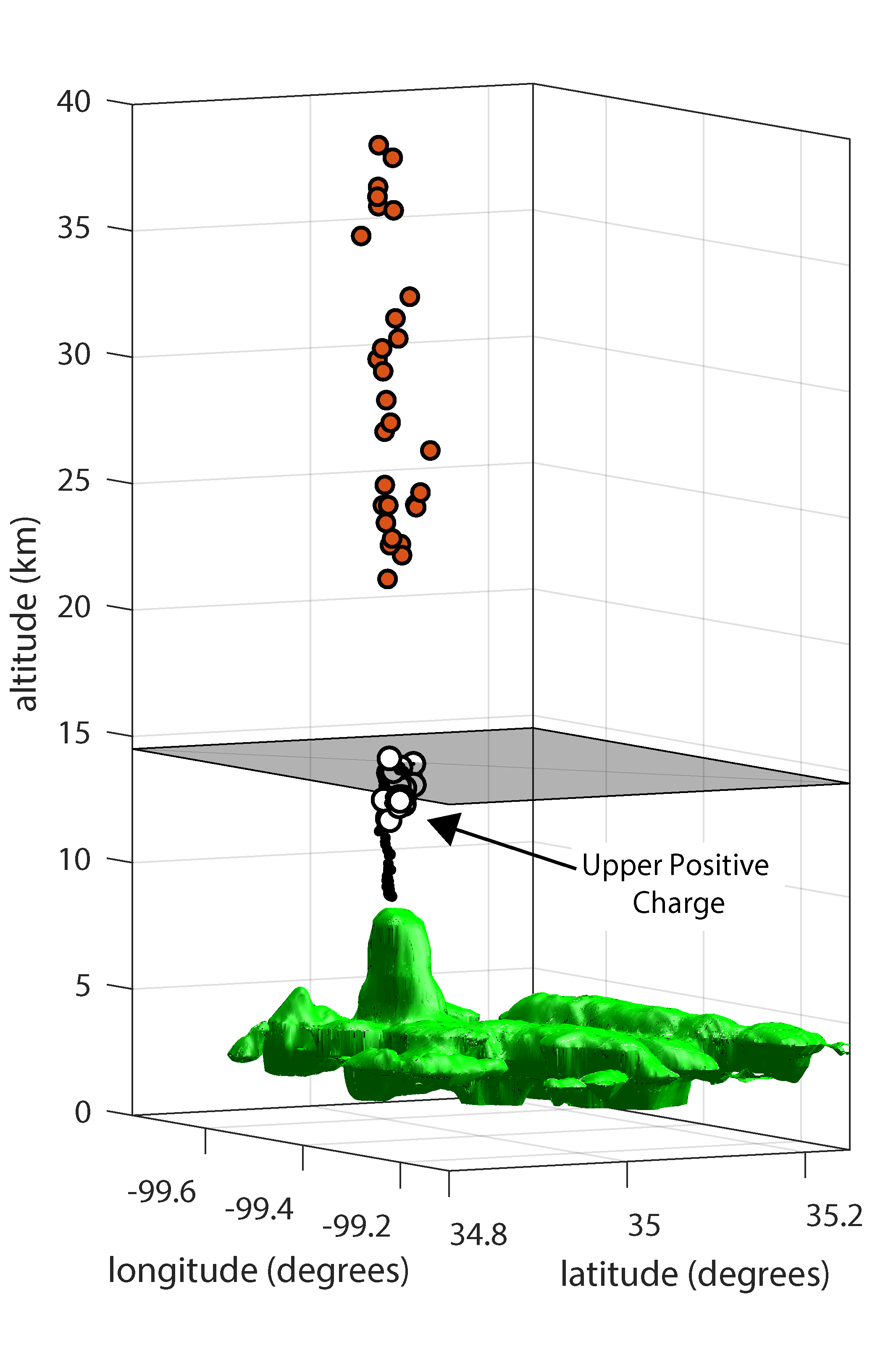
“We were able to map this gigantic jet in three dimensions with really high-quality data,” said Levi Boggs, a research scientist at the Georgia Tech Research Institute (GTRI) and the paper’s corresponding author. “We were able to see very high frequency (VHF) sources above the cloud top, which had not been seen before with this level of detail. Using satellite and radar data, we were able to learn where the very hot leader portion of the discharge was located above the cloud.”
Boggs worked with a multi-organization research team, including the Universities Space Research Association (USRA), Texas Tech University, the University of New Hampshire, Politecnica de Catalunya, Duke University, the University of Oklahoma, NOAA’s National Severe Storms Laboratory, and the Los Alamos National Laboratory. The research is reported Aug. 3 in Science Advances, a peer-reviewed, multidisciplinary, open-access scientific journal.

Steve Cummer, professor of electrical and computer engineering at Duke, uses the electromagnetic waves that lightning emits to study the powerful phenomenon. He operates a research site where sensors resembling conventional antennas are arrayed in an otherwise empty field, waiting to pick up signals from locally occurring storms.
“The VHF and optical signals definitively confirmed what researchers had suspected but not yet proven: that the VHF radio from lightning is emitted by small structures called streamers that are at the very tip of the developing lightning, while the strongest electric current flows significantly behind this tip in an electrically conducting channel called a leader,” Cummer said.
Doug Mach, a co-author of the paper at Universities Space Research Association (USRA), said the study was unique in determining that the 3D locations for the lightning’s optical emissions were well above the cloud tops.
“The fact that the gigantic jet was detected by several systems, including the Lightning Mapping Array and two geostationary optical lightning instruments, was a unique event and gives us a lot more information on gigantic jets,” Mach said. “More importantly, this is probably the first time that a gigantic jet has been three-dimensionally mapped above the clouds with the Geostationary Lightning Mapper (GLM) instrument set.”

Gigantic jets have been observed and studied over the past two decades, but because there’s no specific observing system to look for them, detections have been rare. Boggs learned about the Oklahoma event from a colleague, who told him about a gigantic jet that had been photographed by a citizen-scientist who had a low-light camera in operation on May 14, 2018.
Fortuitously, the event took place in a location with a nearby VHF lightning mapping system, within range of two Next Generation Weather Radar (NEXRAD) locations and accessible to instruments on satellites from NOAA’s Geostationary Operational Environmental Satellite (GOES) network. Boggs determined that the data from those systems were available and worked with colleagues to bring it together for analysis.
“The detailed data showed that those cold streamers start their propagation right above the cloud top,” Boggs explained. “They propagate all the way to the lower ionosphere to an altitude of 50-60 miles, making a direct electrical connection between the cloud top and the lower ionosphere, which is the lower edge of space.”
That connection transfers thousands of amperes of current in about a second. The upward discharge transferred negative charge from the cloud to the ionosphere, typical of gigantic jets.
The data showed that as the discharge ascended from the cloud top, VHF radio sources were detected at altitudes of 22 to 45 kilometers (13 to 28 miles), while optical emissions from the lightning leaders remained near the cloud top at an altitude of 15 to 20 kilometers (9 to 12 miles). The simultaneous 3D radio and optical data indicate that VHF lightning networks detect emissions from streamer corona rather than the leader channel, which has broad implications to lightning physics beyond that of gigantic jets.
Why do the gigantic jets shoot charge into space? Researchers speculate that something may be blocking the flow of charge downward – or toward other clouds. Records of the Oklahoma event show little lightning activity from the storm before it fired the record gigantic jet.
“For whatever reason, there is usually a suppression of cloud-to-ground discharges,” Boggs said. “There is a buildup of negative charge, and then we think that the conditions in the storm top weaken the uppermost charge layer, which is usually positive. In the absence of the lightning discharges we normally see, the gigantic jet may relieve the buildup of excess negative charge in the cloud.”
For now, there are a lot of unanswered questions about gigantic jets, which are part of a class of mysterious transient luminous events. That’s because observations of them are rare and happen by chance – from pilots or aircraft passengers happening to see them or ground observers operating night-scanning cameras.
Estimates for the frequency of gigantic jets range from 1,000 per year up to 50,000 per year. They’ve been reported more often in tropical regions of the globe. However, the Oklahoma gigantic jet – which was twice as powerful as the next strongest one – wasn’t part of a tropical storm system.
Beyond their novelty, gigantic jets could have an impact on the operation of satellites in low-earth orbit, Boggs said. As more of those space vehicles are launched, signal degradation and performance issues could become more significant. The gigantic jets could also affect technologies such as over-the-horizon radars that bounce radio waves off the ionosphere.
Boggs is affiliated with the Severe Storms Research Center, which was established at GTRI to develop improved technologies for warning of severe storms, such as tornadoes, that are common in Georgia. The work on gigantic jets and other atmospheric phenomena is part of that effort.
Writer: John Toon (john.toon@gtri.gatech.edu)
GTRI Communications
Georgia Tech Research Institute
Atlanta, Georgia USA
MORE 2022 ANNUAL REPORT STORIES
MORE GTRI NEWS STORIES
The Georgia Tech Research Institute (GTRI) is the nonprofit, applied research division of the Georgia Institute of Technology (Georgia Tech). Founded in 1934 as the Engineering Experiment Station, GTRI has grown to more than 2,800 employees supporting eight laboratories in over 20 locations around the country and performing more than $700 million of problem-solving research annually for government and industry. GTRI's renowned researchers combine science, engineering, economics, policy, and technical expertise to solve complex problems for the U.S. federal government, state, and industry.


